Fort Dupont Park
Washington, DC | 2012 - 2013
Cultural Landscape Inventory
Project Team: Randall Mason, Molly Lester

History
Fort Dupont was one of the 68 forts built as a defensive ring around Washington, DC at the start of the Civil War. It was sited and designed to support the larger Fort Meigs a half-mile away. It was named for Rear Admiral Samuel Francis Du Pont, who claimed victory in a naval battle in Port Royal, South Carolina, as the DC fort was under construction. (The fort’s name was initially spelled “Fort Du Pont,” in accordance with the spelling of the Rear Admiral’s name. By the mid- to late-1860s, however, it was more often written as “Fort Dupont.”
Fort Dupont, together with the other secondary fortifications in the arc east of the Anacostia River, ensured that the larger fort could withstand an attack and hold out through several days of battle. The fort was initially complete by December of 1861, although its hasty construction necessitated nearly constant repairs and modifications for the duration of the war. The fort (among the smallest of the Civil War Defenses) had a hexagonal perimeter of 200 yards, which encompassed a flagstaff, a bombproof magazine, and a well. Outside the fort, soldiers constructed a barracks to house the garrisoned troops, as well as a mess hall, a guardhouse, and two officers’ quarters. (Cooling and Owen 2010: 216).
Fort Dupont was modified several times over the war, as engineers addressed vulnerabilities in the site’s topography (including the exposed approaches via the ravine west of the fort). General John G. Barnard even recommended that the fort be abandoned in April 1864. His orders were never enforced, however, perhaps due in part to General Jubal Early’s attack on Fort Stevens (in the northern arc of the Defenses of Washington) in July of 1864—an assault that instilled new urgency in the efforts to protect the city.
Despite—or perhaps because of—the alterations, Fort Dupont and the other defenses east of the Anacostia River were never subject to a Confederate attack. Their usefulness as a deterrent was clear, however, as General Early attested after the war. In the latter decades of the nineteenth century, the site reverted to Michael Caton, Sr. and his family, who had owned the farm before the war. The earthworks remained on the site through the nineteenth and early twentieth centuries, even as the Catons and later owners constructed new buildings nearby.
In 1901, the publication of the McMillan Plan (named for Senator James McMillan, who chaired the Senate Commission that released the plan) spurred efforts to preserve Fort Dupont as part of a circle of green spaces around the city. This ring of parks would be established on the former sites of the Civil War Defenses of Washington, as part of the City Beautiful movement’s re-envisioning of the District of Columbia. Fort Dupont was, by this time, surrounded by emerging suburban development, and the site itself featured several buildings west of the earthworks, including a large private residence.
The District’s efforts to acquire the land began in 1913 with the authorization to purchase land for a park. Officials met with some resistance from neighborhood organizations, but the land purchases progressed into the 1920s. During these years, the District Surveyor assessed the buildings on the site and called for the demolition of most of them, with the exception of the main Caton/Brown house that stood west of the earthworks. There was little movement to raze the other structures, however, as the nascent park site was not yet fully open to the public. Instead, the District’s Department of Street Trees and Parking was authorized to use the land around the earthworks as a tree nursery for seedlings, which—once grown—were used to line the roadsides of the city (Robinson and Associates 2004: 77-8). As District park officials assembled the land parcels for the larger park (which opened to the public in the late 1920s), this nursery remained the dominant use of the site around the earthworks as late as the 1940s.
The creation of the park at Fort Dupont corresponded with the formation of the Civilian Conservation Corps during the Great Depression, and in 1933, the first CCC camp to launch in the District of Columbia was established at Fort Dupont Park. The camp itself was located in the northwest corner of the park, opposite the earthworks, but the camp’s laborers worked all over the site—including the portion of the landscape that encompassed the earthworks and was the subject site of this cultural landscape inventory. The CCC projects at Fort Dupont conducted between 1933 and 1941 (within the CLI’s boundaries) included the improvement of the ravine behind the fort; the repair of the earthworks; forest protection in the area around the earthworks; and the construction of a children’s playground nearby.
Analysis + Evaluation
Today, Fort Dupont is situated in the midst of a largely residential area of Anacostia. Its earthworks are somewhat intact, although they have deteriorated. The landscape around the former fort site retains most of the vegetation pattern and the features from its twentieth century conversion to a park, with a cleared hilltop around the earthworks, overgrown hillsides and ravine, and earthworks that feature significant mature tree cover.
Fort Dupont exhibits the following landscape characteristics: topography, spatial organization, land use, buildings and structures, circulation, vegetation, views and vistas, and small scale features.
Topography: The site for Fort Dupont was selected for its topography. Its position 300 feet above sea level provided an elevated vantage of the surrounding landscape, including several strategic sites that Fort Dupont was designed to support and protect. The topography remains the same as it was throughout the historic period, and has a high degree of integrity.
Spatial Organization: Much of the current spatial organization of Fort Dupont dates to the years after the late period of significance. The landscape’s original configuration, with the earthworks on the eastern side of the site and flanking buildings to the west, was disrupted when all of the auxiliary buildings were demolished in the late 1940s. The comfort station was constructed in 1954 (after the late period of significance), which is somewhat consistent with the earlier arrangement of the site. Fort Dupont retains partial integrity of spatial organization.
Land Use: The Civil War era military land use aspect of the Fort Dupont cultural landscape ended when the U. S. government sold the property in 1865. However, the land use of the project area has not changed since the twentieth century period of significance. The site remains a public park, and is used for recreation, education and interpretation, as it has since the CCC era. Land use at Fort Dupont retains integrity.
Buildings and Structures: The earthworks retain their Civil War forms and, although deteriorated, are largely intact as ruins. The buildings from the late period of significance, however, do not survive on the site, and the extant comfort station west of the earthworks dates to the years after the CCC’s projects on the site. The site has partial integrity of buildings and structures.
Circulation: Fort Dupont’s Civil War circulation pattern may partially survive on the site today in the form of limited (and deteriorated) footpaths through the earthworks. The current fort loop driveway around the earthworks was constructed during the twentieth century period of significance and appears to initially follow the route of the nineteenth century road that led from Bowen Road to the Caton/Brown house and the fort’s earthworks. It was repaved, however, in 1950, when the Caton/Brown house was demolished and the house’s circular driveway was removed. Some integrity of circulation remains, in spite of the loss of some features and changes in remaining historic features.
Vegetation: There was limited vegetation at Fort Dupont during the Civil War, in keeping with the site’s strategic design and use. The current vegetation pattern is consistent with the later periods of significance, when the combination of the CCC’s forestation projects and the replanting of former nursery land resulted in the current tree cover on the ravine’s hillsides. In addition, the tree stand near the entrance to the fort loop drive was likely planted by the District of Columbia’s park officials within the twentieth century periods of significance. Vegetation therefore retains some integrity.
Views and Vistas: The views and vistas from Fort Dupont during the Civil War extended to the countryside surrounding the fort—in particular, towards the east and the south. These views remained intact for several years after the war, but were impacted by the redevelopment of the site and surrounding area in the twentieth century. In addition, during the late periods of significance, vegetation growth within the site has also affected the important historic views. Therefore, present day views retain no integrity to the period of significance.
Small-Scale Features: None of Fort Dupont’s small scale features date to the periods of significance. The existing small scale features have been installed since the historic period and include wayfinding, regulatory, and interpretive signage, as well as several picnic tables and benches on the site. These features are consistent with the site’s land use during the twentieth century periods of significance, and so are compatible but non-contributing.

1861: Boschke map of the District of Columbia, with future hilltop site of Fort Dupont highlighted. (Library of Congress, Geography and Map Division)

Comparison of the 1861 Boschke map (left) with the 1861 Lines of Defense map (right), developed by Major General John G. Barnard. Barnard’s map of the fortifications around Washington used Boschke’s survey as a base map, superimposing the location of the hastily-built forts on the existing map. (Boschke map, Library of Congress, Geography and Map Division; Lines of Defense map, Historic Map Works Rare Historic Maps Collection)

Engineer drawing of Fort Dupont (National Archives, as printed in Mr. Lincoln’s Forts)

1888 map of the site, indicating presence of Caton/Brown house (at center of driveway) and intact earthworks (north of the house). (NOAA Historical Map and Chart Collection)

1903 Baist map of the site (owned by Sophia H. Brown at the time the map was surveyed), which indicates the continued presence of the Caton house on the site, as well as several smaller frame structures north and east of the house (in the vicinity of the earthworks, which—as natural features—were not mapped by the surveyors). (Library of Congress, Geography and Map Division)

Fort Dupont entrance in 1932 (top) and today (bottom left and right). The taller walls along Alabama Avenue in 1932 (top) are no longer standing today (bottom left). The shorter walls that edge the bridge over the swale (center of top photograph; bottom right) were rebuilt in the early 1950s when the bridge was replaced. (Top: Office of Motion Pictures, United States Department of Agriculture; Bottom: M. Lester, 2012)

Map and aerial photographs showing the changes in circulation features from 1919 (left) to 1988 (center) and 1999 (right). This includes changes in the footpaths and in the fort loop driveway. The secondary loop in the driveway, which in 1919 diverted around the Caton/Brown house and in 1988 around a cleared area where the house formerly stood, lasted into the 1990s. By 1999, a parking area was inserted west of the earthworks and the secondary loop of the driveway was removed. (Library of Congress, Geography and Map Division; United States Geological Survey, via Google Earth; District of Columbia GIS, via Google Earth)

Current conditions of the fort loop driveway, including the entrance spur (left) and the exit spur (right). The two spurs meet at the park’s Alabama Avenue entrance. (M. Lester 2012)

Extant fragments of a cement path west of the earthworks. This circulation is consistent with aerial photographs from the end of the second period of significance (1901 to 1927) that show paths connecting the various auxiliary buildings and tree nursery portions of the site. (M. Lester 2012)

Maps from 1884 (left) and 1888 (right) of the hilltop where Fort Dupont’s earthworks were constructed. The clearcut vegetation pattern, particularly on the west side of the hill, is consistent with the army’s treatment of the fort sites around Washington. This allowed for clear views toward the other forts and the city center. (NOAA Historical Map and Chart Collection)

Existing vegetation conditions on the site, including the open grassy area (with specimen tree plantings) surrounding the earthworks (top) and the dense tree cover and growth covering the earthworks (bottom). (M. Lester 2012)

These rows of specimen red cedar trees, located west of the earthworks, reflect the site’s temporary twentieth-century use as a tree nursery. They likely edged one of the auxiliary structures on the site. (M. Lester 2012)

View from east of the earthworks, looking west at the specimen tree plantings (which date to the twentieth century periods of significance, as the site was converted to public parkland), the fort loop driveway, and the earthworks in the background. (M. Lester 2013)

View of the west side of the earthworks from the parking area (top) and parapet walls within the earthworks (bottom). The trees on this side of the fort’s hexagonal perimeter were removed in recent decades to allow for a view of the earthworks from the parking and picnic areas. Without the buffer of tree roots, the soil on this side of the earthworks has eroded from the parapets at a faster rate than the other sides of the fort. (M. Lester 2012)
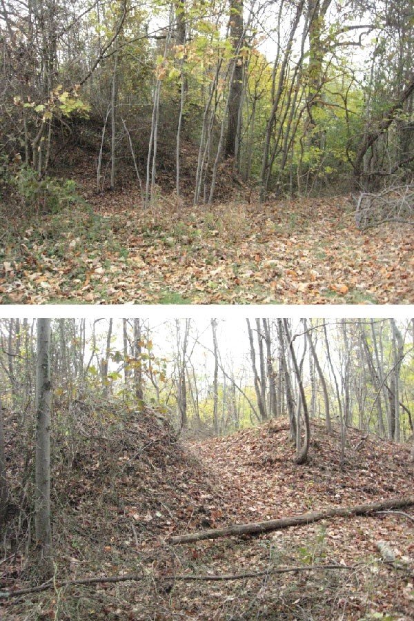
The extant earthworks are still topographically legible. Features such as the parapet walls and surrounding ditches (top) and the collapsed magazine (bottom) are clearly visible, despite the presence of dense undergrowth and mature tree cover on much of the fort today. (M. Lester 2012)

The picnic area (top) and comfort station (bottom) on the site today are non-contributing features that were installed in the 1950s, after the end of the second period of significance. They occupy the portion of the hilltop that is west of the earthworks and the fort loop driveway. (M. Lester 2012)

The existing views and vistas from Fort Dupont are obstructed by growth on the earthworks, including dense underbrush and mature trees. This disrupts any integrity of views from the fort, which originally looked towards the other defenses (to the north and south) and the city center (to the west). (M. Lester 2012)

The commemorative boulder and plaque along the western edge of the earthworks were placed at the site in 1955 by the National Society of Colonial Dames. It was installed to mark the history of the fort and the significance of the Defenses of Washington, but was presented after the end of the late period of significance and is therefore a non-contributing feature. (M. Lester 2012)