Fort McNair
Washington, DC | 2020 - 2021
National Register Nomination Update
Project Team: Randall Mason, Molly Lester, Joshua Lewis, Margaret Sollmann

Summary Statement of Significance
(NRHP Section 8)
Originally designated as a military fort by Pierre L’Enfant in 1791, the Fort McNair Historic District has remained in continuous use as a U.S. military installation for 230 years. In addition to its role as a strategic waterfront fort protecting the nation’s capital, the historic district was the site of the Washington Arsenal, the U.S. Penitentiary, the Washington Barracks, Army General Hospital, the military’s Engineer School and Army War College, and the Army’s General Headquarters (GHQ), and the World War II-era Armed Ground Forces (AGF)—all of which contribute to its national significance under Criterion A, in the areas of Military, Education, and Politics/Government. The historic district is also associated with the groundbreaking research of U.S. Army physician Walter Reed on the root causes of airborne diseases such as malaria and yellow fever; Fort McNair Historic District is nationally significant under Criterion B based on the association with Reed’s life, work, and death. The historic district is also nationally significant under Criterion C as a major work of renowned architecture firm McKim, Mead and White; the firm was responsible for a complete redesign of the fort’s site plan in the early 20th century, as well as the design of most of the fort’s extant buildings, which adapted the Beaux-Arts style according to a military hierarchy. The historic district is also locally significant under Criterion C based on the fort’s surviving works by architect Adolph Cluss, whose redesign of Building 20 was considered important enough to incorporate into McKim, Mead and White’s overall plan, rather than demolish. Finally, the fort is significant under Criterion D based on its potential to yield archaeological information associated with its periods of use as both the Washington Arsenal and the U.S. Penitentiary.
The historic district’s period of significance begins in 1791, based on the formulation of the L’Enfant Plan, and extends continuously until 1945; the relocation of the Armed Ground Forces from the historic district to the Pentagon marks the end of the period of significance. Fort McNair Historic District’s function, design, continuous use, associations, and architects represent nationally significant narratives in the history of the United States and its military.
Summary Description
(NRHP Section 7)
The Fort McNair Historic District is located on Greenleaf’s Point, a peninsula in the southwest quadrant of Washington, D.C., overlooking the confluence of the Anacostia and Potomac Rivers. Hains Point is directly to its west (on the opposite side of the Washington Channel), and the U.S. Capitol and National Mall are approximately one mile due north. The historic district is oriented north-south and comprises most (but not all) of the property associated with the present-day military installation at Fort McNair (part of Joint Base Myer-Henderson Hall). The historic entrance to the fort was located at the northern boundary, at P Street SW, within the boundaries of the historic district; the fort’s primary entrance is currently located on its eastern boundary, at 2nd Street SW (outside the boundaries of the historic district).
Fort McNair was originally designated as a military fortification by Pierre L’Enfant in 1791, and remains one of the nation’s oldest military installations in continuous use. The extant layout of the site is largely attributable to an early-20th century redesign of the fort by the architectural firm of McKim, Mead & White. In addition to their role in the redesign of the campus landscape, McKim, Mead & White also designed most of the building and structure resources within the historic district; the architects selected Beaux Arts as the dominant style.
The campus plan for the fort, as redesigned by McKim, Mead & White, is characteristic of what would later be called the “four square and austere” design of military installations of the early 20th century: buildings arranged around the perimeter of an open, rectangular parade ground. This design also echoes collegiate plans—consistent with the fort’s historic use for military education—where campus buildings are arranged around an open green, with a library or similar building as a focal point; at Fort McNair, the McKim, Mead & White redesign introduced the Army War College building (Building 61/Roosevelt Hall) as that focal point at the southern end of the peninsula. Designed at the height of the Ecole des Beaux Arts’ influence on site planning, the landscape design employs Beaux-Arts principles such as axial symmetry and linear, unbroken perspective looking south from the historic entrance on P Street SW. Although McKim, Mead & White intended for the campus’ sightlines to extend south to the War College, they are interrupted by Buildings 17, 20, and 21, which pre-date the McKim, Mead, & White plan and remain in place on the site today. With Italianate and other 19th-century stylistic features, these buildings represent earlier periods of architectural development than the rest of the Beaux-Arts site, as designed by McKim, Mead & White.
The primary building material within the historic district is red brick, often arranged in Flemish bond or common American bond; according to a report of the U.S. Army’s Chief of Engineers, this choice was made for economic reasons and “also because it seemed more in keeping with military simplicity.” Because the peninsula was so marshy, the Army Corps deployed new methods for the concrete foundations, using a newly-patented strategy that involved driving steam pipes of 12-16 inches in diameter, filling them with concrete, and then removing them as the filling progressed. Primary or visible roofs are typically slate, while secondary roofs (on porches, etc.) were historically constructed with flat lock copper or standing-steam metal. The architectural ornament on the buildings is restrained, and is usually limited to sheer masonry belt courses or brick corbelling along cornice lines or window lintels.
The Fort McNair Historic District was determined eligible for listing in the National Register of Historic Places in 1978. This nomination clarifies and updates the previous nomination, and includes expanded documentation of the landscape context and site features within the district. The boundaries for this updated nomination are consistent with the previous nomination’s boundaries, as determined eligible in 1978.

The 3rd Avenue entrance allée, looking south from the Six-Gun Gate toward the parade ground.

View looking south from the 3rd Avenue allée toward the flagpole area and the parade ground/drill field.

View across the parade ground.

View across the parade ground (and significant historic cannons) toward the officers' quarters (1-15) designed by McKim, Mead and White.

View from the parade ground/drill field looking east toward Quarters 23-28.

View of Quarters 1 (at right), 2, 3, and 4 (at left), looking southwest.

View of Building 54, looking northeast. Building 54 is located on the northwest side of the campus, just north of B Road and east of 1st Avenue. The building was originally constructed in the Second Empire style by a series of contractors from 1893-1898 as the General Hospital on post, and was converted into barracks in 1908.

View of Building 17, looking northeast.

View of Building 20/Grant Hall, looking east. Originally part of the U.S. Penitentiary, Building 20 was where President Lincoln’s assassins were held and tried in 1865 (before being executed on the site of the tennis courts, immediately west of this building). Building 20 was fully renovated from 1869 to 1871; D.C. architect Adolph Cluss oversaw its rehabilitation in the Italianate style.

View of Building 61/Roosevelt Hall, looking southeast. The most significant McKim, Mead & White design on-site, the building was originally constructed as the Army War College and is currently occupied by the National War College. Secretary of War Elihu Root set aside the land for the Army War College in 1901, and the cornerstone was laid in February 1903. Congressional approval in 1904 allowed construction to begin in earnest, and in 1907, construction was completed at the cost of $700,000. On June 30, 1907, the College officially opened. The building is located at the south end of campus (and historic district) fronting D Road and only a few hundred feet north of the confluence of the Washington Channel, the Potomac River, and the Anacostia River. It is centrally located on the peninsula’s longitudinal axis, in line with 3rd Avenue, in order to make the building the focal point of the views from the northern end of campus. The Beaux-Arts building was individually listed on the National Register of Historic Places in 1972 (NR #72001535).
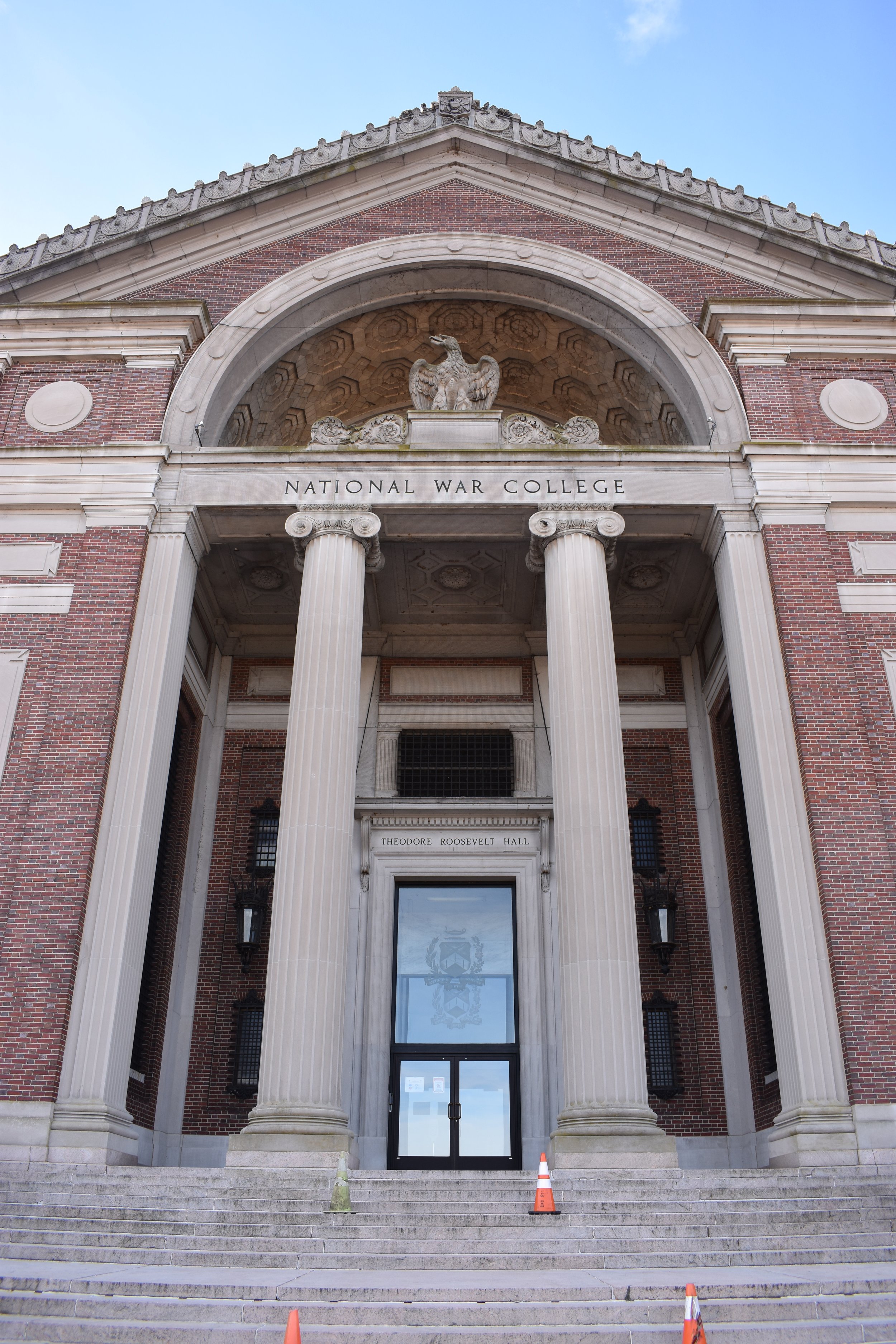
Entrance portico of Building 61/Roosevelt Hall.

Interior view of Building 61 conference room, with Guastavino tile vaults.